Alderney
For FSX
Developed & Published by Earth
Simulations
Reviewed by Joe (Mutley) Lawford
April 2009
Introduction.
Alderney, for those not familiar with the name, is a country 9 miles due
West of Cap de la Hague in Normandy, France. It is part of the Channel
Islands group governed by the Baliwick of Guernsey and a British Crown
dependency, it’s the closest island to “mainland” Britain being only 60
miles away from the Isle of Wight.
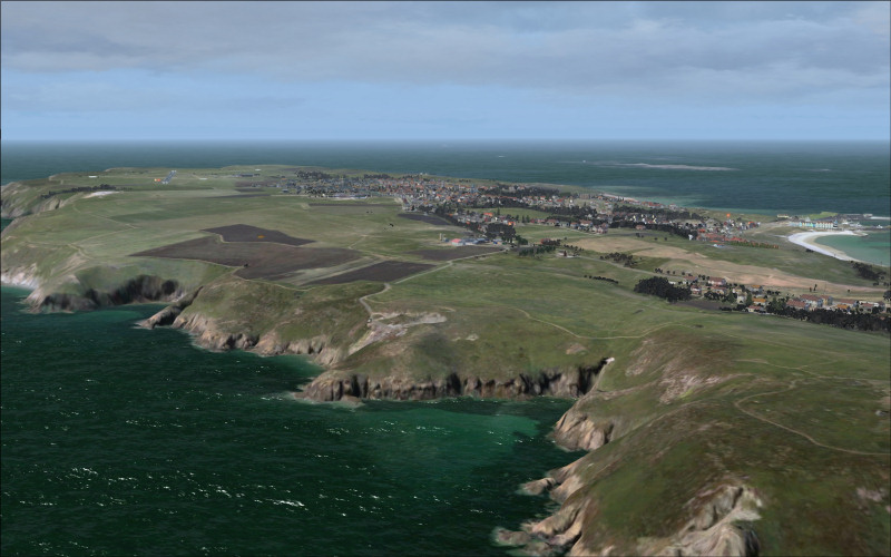
Alderney is the third largest of the Channel Islands, it is roughly 3 miles
long by 1½ at its widest, about 2,000 acres in extent and is situated in the
mouth of the Channel, 9 miles due West of Cap de la Hague in Normandy. It
has high cliffs along its Southern coastline, with the main plateau area,
about 80m high, having most of the agricultural land and sloping steeply
down to the North and East. Along the Northern coastline you will find
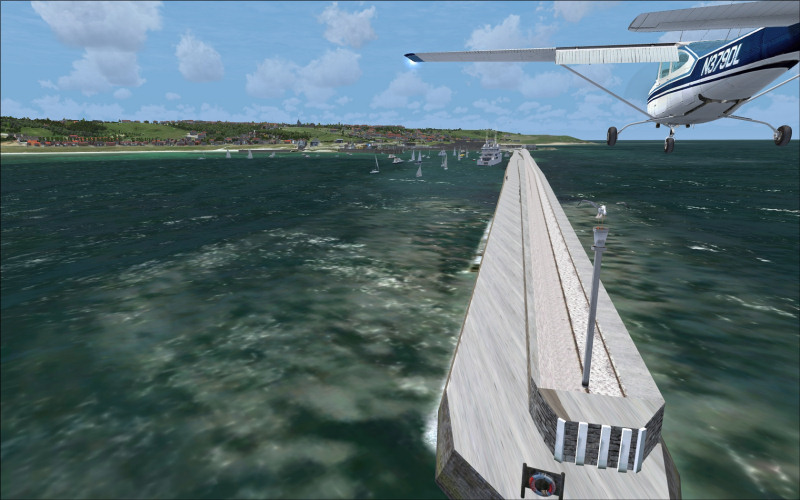
beaches in three small coves and a protected harbour in Braye Bay that has a
breakwater 870m long. Originally the breakwater was 1430m but was lost in a
severe storm in the 1840’s.
Alderney can also be closely associated with it’s own airline, Aurigny (The
Norman name for Alderney) and their 8 Britten Norman BN2A Mk III Tri-landers,
themselves built on the nearby Isle of Wight. The airline also operates 3
French built ATR 72-300’s.
About the developer
Earth Simulations is the brainchild of its joint owner and developer Darren
Vincent and his wife Vikki. Anyone familiar with the movers and shakers in
the British VFR scenery market will recognise Darren as the lead developer for 3d
modelling and water masking for Horizon Simulation.
Darren and Vikki now have a mission to develop the highest quality, most
innovative, scenery there is possible for flight simulation with attention to
detail and performance often overlooked by others
This scenery is the first in a series of three, to be followed up by
Guernsey, Herm & Sark and finally the jewel in the crown, Jersey.
About the software.
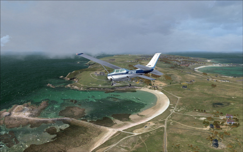
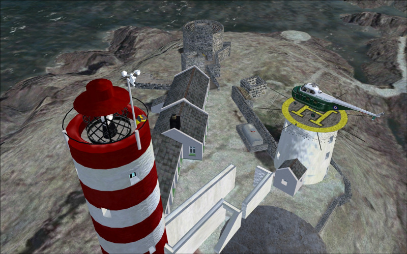
Included is the island of Alderney and outlying rocks, most notably
the
Casquets that also feature a landable
lighthouse. Also included is custom EGJA airport scenery, photoscenery and autogen. The data
is provided by Digimap and officially licensed from the Guernsey and Jersey
governments
The scenery is basically in two layers:
|
Topography layer |
|
|
|
Environment layer |
|
|
Installation
After purchase from their own online store a link and unlock code is
provided by email.
When running the installer, the user is asked to input their unlock code before the
program will move on. The installer offers a choice of disc location; the ES
scenery folders are located within their own ES subset of folders and a
backup taken of essential FSX files taken at the same time, this is quite
reassuring.
Entries into the scenery.cfg file and activation of the scenery layer are
automatically done. So within around 5 minutes you are ready to go.
Performance and use.
The supplied manual offers a lot of common sense advice on the display
options. To see the full detail you will need to run the complexity and
density at max. Having said this, stepping it back a notch won’t affect your
enjoyment by any means. Surprisingly, without tweaking, I had a really smooth
flight. Even in tight turns, which for me are the worst culprit, I still
enjoyed a respectable frame rate. Looking through their user forums appears to
substantiate this fact with little or no mention of performance problems.
It is worth taking the time to play with the display settings as there will
be a setting that works for you. This is VFR eye candy at its best so really
you should only be flying at a leisurely pace, otherwise you will miss some
of the finer touches!
The base photoscenery and mesh is very detailed,
this can be born out in the cragginess of
the cliff faces and
other little facets that would just be a
round lump in the default scenery. Even without autogen,
you would still have a product that is very usable and detailed in its own right.
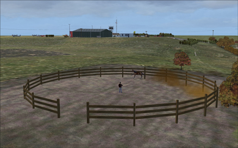
The scenery, both topography and environmental, is seasonally aware; this is
a feature I have not seen anywhere else to this extent. In spring you will
notice blossoming trees, yellow fields of Rape Seed and tractors spraying
the fields. In Summer, a paraglider can be seen off the coast riding the
thermals.
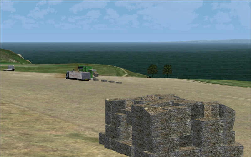
The Autumn brings in slightly darker textures and ploughed fields.
A combine harvester can be seen ejecting bails of hay for a waiting lorry
and a JCB dumps scoops full of soil into a lorry.
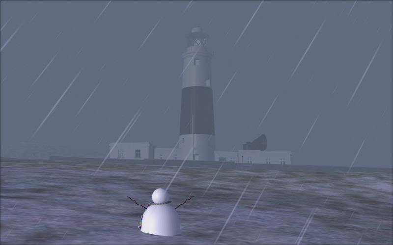
Hard winter is one of the
most breathtaking transformations of the scenery. In January the ground is
covered in a layer of snow. As you would expect a snowman appears to delight
the viewer, a vast majority of the trees are white and it feels really cold!
|
|
|
|
|
|
I mentioned earlier about the 3d autogen, there really is too much included
and
to list them all would only spoil your enjoyment of discovering them. The objects are totally custom made,
there are very fine models of both
the Mannez Lighthouse (situated on the East of the island) and out to sea on
The Casquets rocks, to the northwest of Alderney.
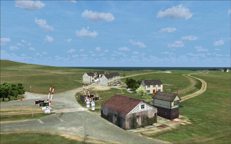
Other landmarks are
modelled too, St Anne’s Church (Complete with congregation), forts, the
breakwater, which has now become a popular landing place in the flight sim for
light aircraft and must really annoy the locals!
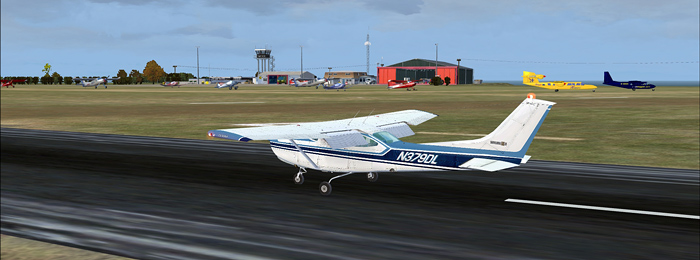
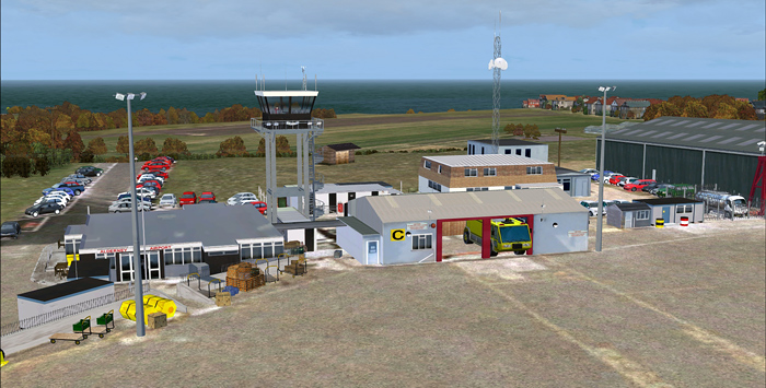
Alderney airport is also included in great detail. There are 2 grass runways and
one tarmac, great for practicing your touch and goes. Runway 08/26 at
2887ft is the longest so that helps to keep out the bigger commercial rif-raf!
The control tower features an animated ATC taking his direction from the
VAIO monitors! Yes, it is that thorough, I wonder if that's reality or
just wishful thinking on the developers behalf?
When night falls the scenery does not stop performing, the transformation to
a night scene is stunning and being a relatively small island the sea is
always going to give you a good sunset. When the night textures kick in the
level of detail is equally impressive.
Individual street lights, windows in
the houses and the stained glass in St Anne’s comes to life. Of course, as
you would expect with scenery of this quality, the lighthouse lamp rotates
and can be seen from all over the island if you are high enough.
You wouldn’t really expect to find so many interesting features in
such a small
island. This is one of my most flown to and from destinations recently and
will remain so for a long time. I am honestly still finding little features
and details I had not noticed before!
There are a few minor problems with the water mask around the craggy
coastline, it can be seen on very close inspection but is really just
nit-picking, you may find that the default AI boat traffic will try to
scupper itself on the rocks near the lighthouse, the trouble is the AI
really needs tweaking to fix this. A visit to the user forum will tell
you how.
Summary
The combination of HD scenery and excellent performance is going to keep you
coming back for more. The painstaking attention to detail did not go
unnoticed, this has to be the very best in its genre, well done Darren &
Vikki.
The good news is the other two scenery packages are not that far over the
horizon! (Pun intended)
Oh and how much? £14.99 + VAT that’s just a bargain!
Joe Lawford
LINKS
Earth Simulations Home :
Product Page :
User Forum