Madeira X
For FSX Published by Aerosoft
Reviewed by Joe Lawford
August 2009
Introduction
Set in the Atlantic Ocean c.350 mi (560 km) off the coast of Morocco,
Madeira is the largest island in the Portuguese archipelago and is
accompanied by another populated island, Porto Santo. Two other islands
Desertas and Selvagens are also part of the group but are relatively small
and uninhabited.
Madeira:
The landscape is dominated by mountain ranges with the highest peak being
Pico Ruivo 1832m (6046ft). Deep valleys cut their way down to the coast and
on the northern side terminate in high cliffs. The volcanic origins of
Madeira can still be seen, the amphitheatre that surrounds Funchal was once
a caldera
![]()
Until comparatively recently Madeira was covered in ancient subtropical
rainforest. Indeed this is the reason for the name of the island, 'Madeira'
meaning 'wood' in Portuguese.
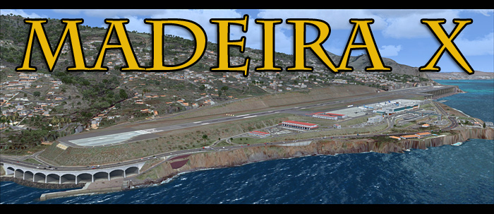
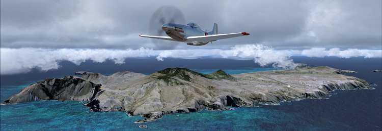
The airport aka "The Airport on Stilts" is perched on the south-eastern coast and has a notorious
challenging approach to rwy 05, a runway of 2871m (9419 ft).
Porto Santo:
15 minutes away by air from Madeira is Porto Santo. Described by its tourist
department as "One long beach with a bit of an island attached" is not
strictly true but probably subliminal comparison to Madeira which has
practically no beaches.
The island's topography includes farmlands in the southern and central
parts, forests and mountains along the north-eastern part with around six
main mountaintops including Pico do Facho (literally 'Peak of the Torch')
which is, at 516m (1703ft), Porto Santo's highest point.
The airport almost splits the island in half running roughly north south.
Built before its neighbouring islands airport in 1960, the runway has been
extended in stages to its current length 3000m (9843ft) so has opened it up
to all types of aircraft.
Comparisons between real world and FSX
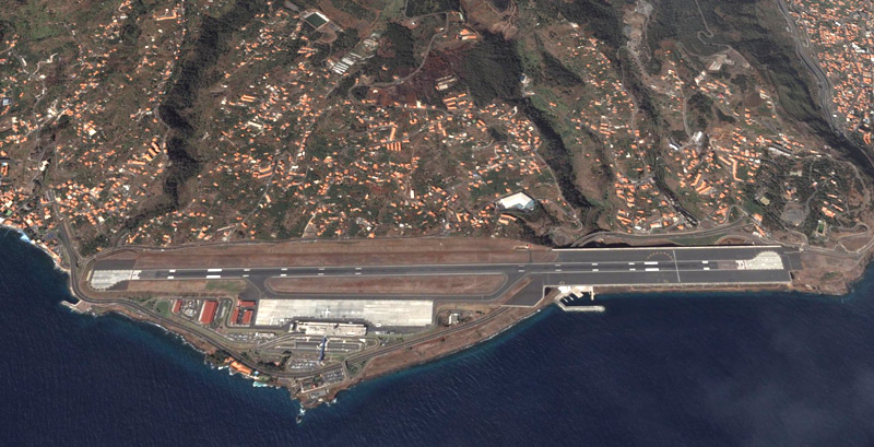 MADEIRA -FUNCHAL LPMA IN THE REAL WORLD Click to enlarge image |
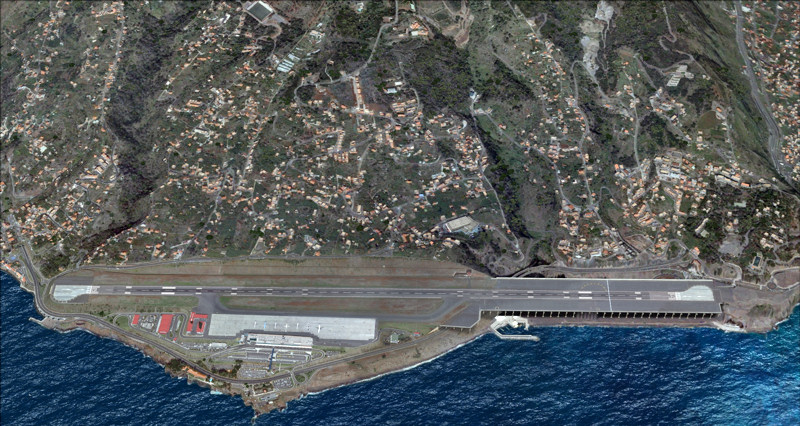 MADEIRA -FUNCHAL LPMA IN FSX Click to enlarge image |
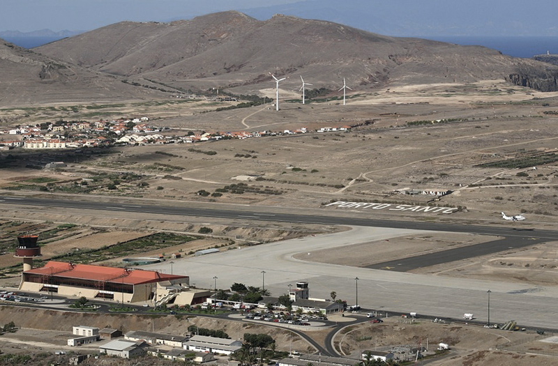 PORTO SANTO LPPS IN THE REAL WORLD Click to enlarge image |
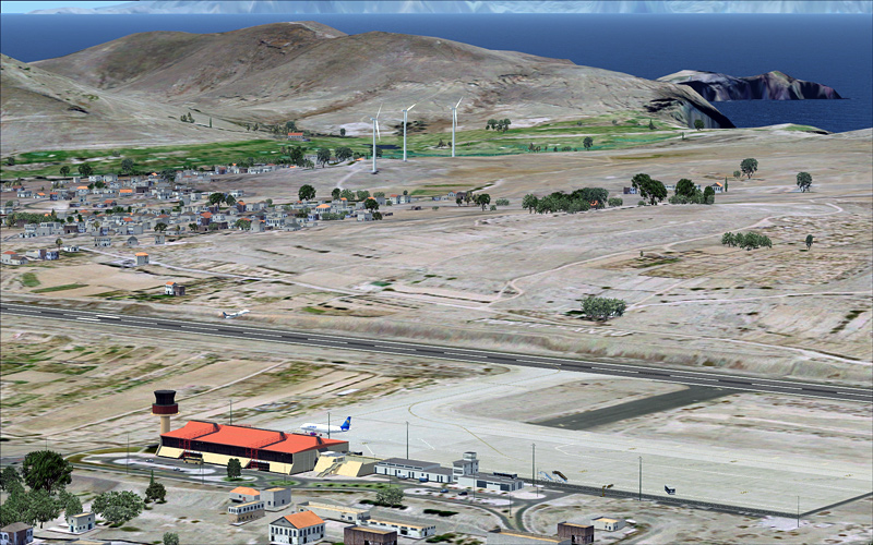 PORTO SANTO LPPS IN FSX Click to enlarge image |
The product.
Madeira X for FSX from Aerosoft, is a
brand new product from a different developer than the 2004 version. So it is
built from the ground up (So to speak), as well as the scenery there is a
user manual and airport chart pdf's included, after installation they can be
found in the FSX/Aerosoft folder.
Being a previous user of Wonderful
Madeira for 2004, when asked to review MadeiraX I thought it will not take
that long as it cannot be that much different? I was very wrong, after a
couple of weeks l have managed to pull myself away from the sim long enough
to write this article!
 Highly detailed mountainous regions Click too enlarge image |
Madeira boasts these features: • Photo realistic 50 cm pixels ground coverage • Highly detailed airports of Funchal (LPMA) and Porto Santo (LPPS) • Super detailed 9,5 metre mesh • 120,000 hand-placed autogen objects • Dozens of detailed VFR objects (bridges, wind power plants etc) • Dynamic traffic on all highways • AI Traffic (compatible with MyTraffic) • Extensive manual with charts |
Installation.
The product is available in both download and dvd versions. My installation
was from a download. At 1.3Gb it took a while to download on my connection but
the server delivered the file without problems.
Installation followed a familiar pattern installing into Aerosoft's FSX
folder. I like this as I always know where to find their scenery
files. With online activation using a keycode we were ready to go.
|
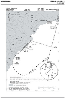
Manuals & Charts The user manual is full of recommendations for display settings and shows examples from each tab. (More below) A target FPS of 22 is recommended and is a realistic and achievable target. On my review machine I use a third-party program called FPS limiter, here I set my FPS and leave FSX at unlimited. For me, this stops stuttering caused by my set up, not the program. One thing I really liked were the included charts, for both islands. Aerodrome, parking, SIDS & STARS, visual and instrument approach and my favourite, the detail of the curved approach, staring at the "Gelo" beacon and finishing at "Rosario", by this time you should have Rwy 05 straight ahead or it's the missed approach procedure! You may want to print some of these charts out, especially the approach charts as trying to alt-tab to the pdf document at the wrong time could spell disaster. |
 |
Setup.
If you have a mid to high end machine and
you are an experienced user you will be familiar with editing the FSX.cfg
file. To get the absolute best from the program I would recommend a couple
of tweaks, MipBias=7 (or a range from 5 -9 ) this needs to be entered in the
[Display] section and the [Display.Device.{your graphics card}] section. The
overall affect of this setting is to increase the far focus of the textures.
The second tweak is to increase the level of detail setting (LOD) in the
[TERRAIN] section. By default if you have the level of detail slider in the
sim set to large then this results in a LOD_RADIUS=4.500000 . The shots in
this review are taken with a setting of 8.500000 so you may have to keep
tweaking it up or down until you get your best mix of quality and
performance. One point to note however, if you set the
LOD_RADIUS higher than 4.5 every time to change a display setting in the sim
then this gets reset back to 4.5.
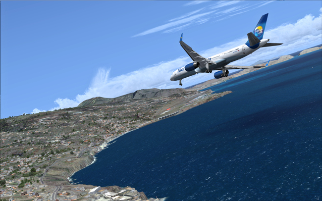
PORTO SANTO FROM THE SOUTH EAST
Touring the islands
As mentioned above, Porto Santo is the smaller of the two populated islands
in the Madeira archipelago. The detail of the mountainous peaks is very good and
the remnants of the rainforests can be clearly seen. There are some
stretching effects on the shear cliffs near the coast which detracts
slightly from the quality. The westernmost peak overlooks the airport
and is a good viewing point to watch the comings and goings of the airport.
The southern shore is one long beach, there is a harbour where cruise liners
dock, so something to add interest. The autogen is well chosen and I would
say, about the
right level of density.
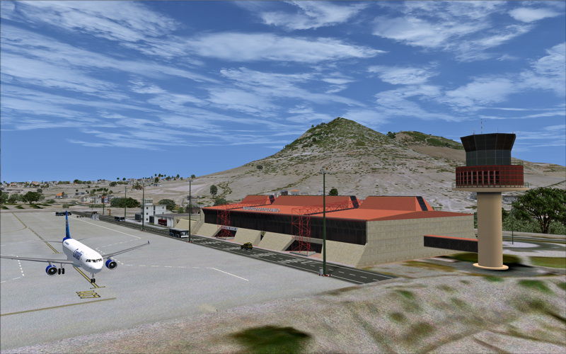
The airport has quite a modern looking terminal and tower. What looks to be the
old tower and terminal are adjoining the new buildings further up the apron.
LPPS has a Doppler VOR/DME
not far from the threshold of runway 36 as well as an NDB nearby. The runway
has PAPI lighting as well to guide you in. To the northern end there
is a military facility and a single hangar.
The island is quite a bland colour as it is in real life and this is
accentuated by the verdant green of the golf course. Overlooking the airport
there are three huge animated wind turbines, these dominate the local landscape.
In all a very nice and believable representation of this often over-looked
island, after using this scenery I could spend a couple of days there
exploring the real world island.
 SPOT THE GOLF COURSE! Click to enlarge image |
 PORTO SANTO NEW TERMINAL WITH MOUNTAINS BEHIND Click to enlarge image |
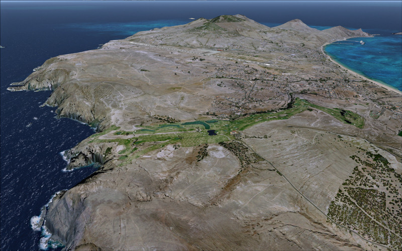
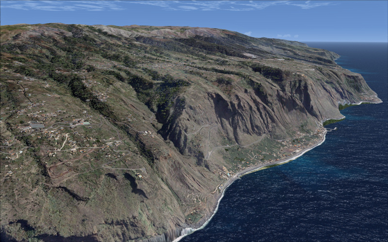
Madeira is a whole lot more mountainous than Porto Santo. This means
that there is far more detail to be displayed, the 9.5m mesh does a great
job and is a huge improvement on the default, however had they used a 5m
mesh then it would have been awesome, I guess this depends on what SRTM data
there is available and possibly a prohibitive price?
As you can see from my shots I am being very picky as this is already prime
screen shot territory, the combination of photo textures, mesh and autogen
make VFR flying an absolute joy.
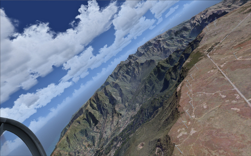
The cliffs along the northern coast suffer from the same stretching
appearance as it does in Porto Santo but is a lot more noticeable as the
cliffs are so much higher and longer. For me, this looses the scenery
some points as it is so noticeable when flying low and slow.
 INCREDIBLE DETAIL IN THE VALLEYS Click to enlarge image |
 A SOCCER PITCH IN THE HILLS AND ROADS RUNNING ALONG THE RIDGES Click to enlarge image |
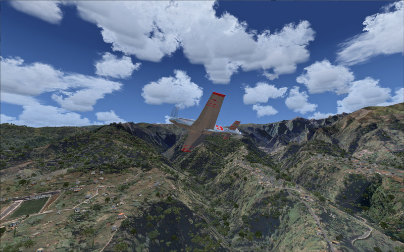
There is plenty to make up for it though, there is
incredible detail in the photo scenery, I have seen it written in many
places that the locals and visitors alike can point to a place and say that
IS what it is like in real life. That is a great testament to the
developer and the quality of the product
Most of the northern and western
districts are situated in high
ground, the whole area is dominated by a wind turbine farm of around 35
windmills (Yes I counted them!) The ground slopes away to the sea where not many of the population
live but they have some wonderful panoramas.
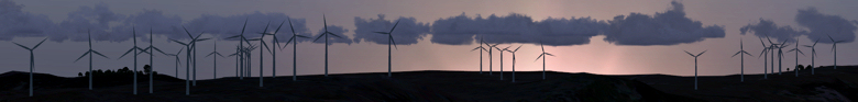
At night, these turbines have red flashing beacons in the hub centre of the
blades, they can be seen miles away and is very dis-orientating until you
realise what they are!
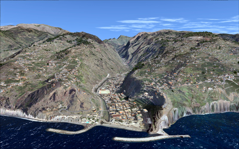
Working our way around to the south we see more densely populated areas.
There are several marinas along the shore and I found a beach! Not that long
and over-shadowed by those ominous cliffs!
 BEACHES CAN BE FOUND MOSTLY NESTLING AT THE BOTTOM OF CLIFFS Click to enlarge image |
 THAT VALLEY IS FAR TOO TEMPTING NOT TO FLY UP! Click to enlarge image |
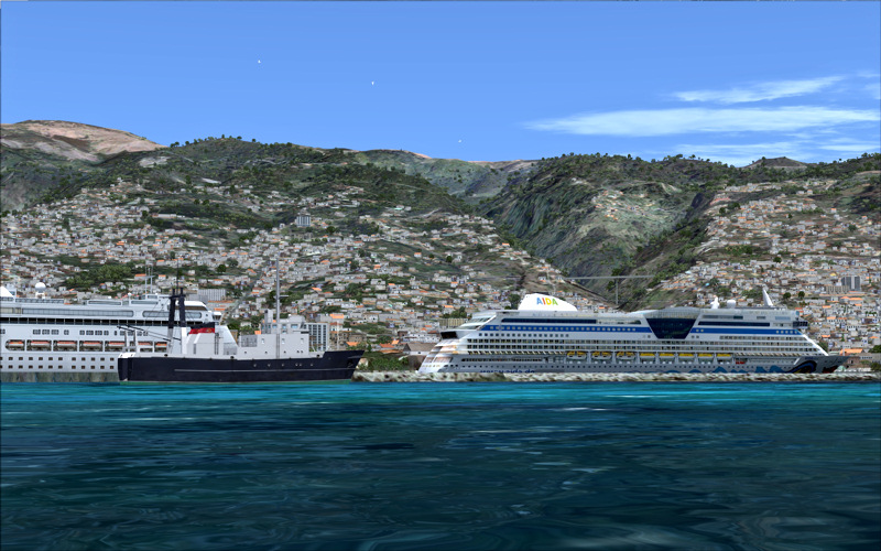 CRUISE LINERS FILL THE HARBOUR Click to enlarge image |
 PORTUGUESE MAN O' WAR? Click to enlarge image |
Finally, let's turn our attention to the
airport. For those amongst us who are not concerned with eye-candy (Then why
are you considering this scenery!) this will be the main attraction.
The runway is slightly shorter than that of Porto Santo and twice it's
original length thanks to the extension that sits upon a series of 180
concrete columns. This gives the airport it's distinctive look that
makes it an un-mistakable location.
Again we have a CVOR/DME and NDB to tune into. PAPI lighting guides you in
from both directions. Runway 05 has the notorious curved approach
where on the base leg you aim at a light beacon called Gelo then tightly
turn to starboard following the beacons to Rosario, by now the runway is in
sight and o-so close! The prevailing winds rushing down from the
mountains make it a challenging approach for the most experienced of pilots.
KEEP THE FAITH BROTHER!
The night lighting will not disappoint, both on approach and on the apron it was well represented. The rest of the scenery has night textures too just to add that feeling of life going on into the night.
 THE ELEVATION IS 341 FT SO KEEP ABOVE THOSE YELLOW CHEVRONS! Click to enlarge image |
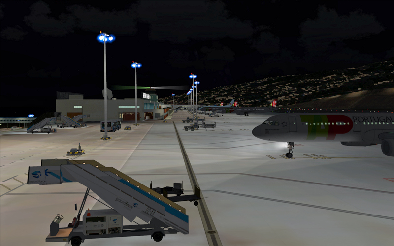 NICE DETAIL AND CLUTTER ON THE APRON, THE LIGHTING IS SPOT ON Click to enlarge image |
Conclusion
It's obvious that a lot of time and attention to detail has been spent on
this scenery. A true classic in it's genre. There's no point anyone
else making scenery for Madeira as Aerosoft have been there, done that!
You know anything else is just a compromise!
/Joe Lawford
|
|
|
|
LINKS |
|